Pop-up Bike Lanes Program
We’re trialling up to 100 kilometres of new and improved pop-up bike routes across key inner-Melbourne suburbs to make it easier and safer for people to ride to and from the CBD.
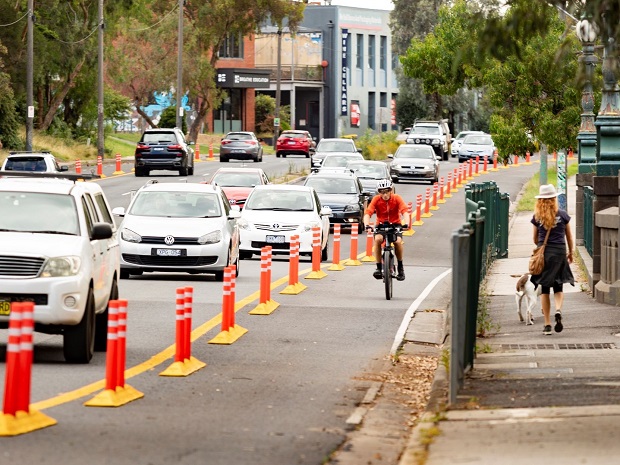
In 2022 we installed temporary bike infrastructure along Marine Parade as part of the Pop-up Bike Lanes Program to improve safety and connectivity on one of Melbourne’s busiest commuter bike corridors.
We installed sections of separated bike lanes, green surface treatments, signage and line markings along Marine Parade to improve safety and raise awareness of people on bikes.
We’re now consulting with the community to determine the next steps for Marine Parade.
Visit the Engage Victoria website to provide your feedback.
The trial has now ended and evaluation is complete.
Here’s what we found
The numbers
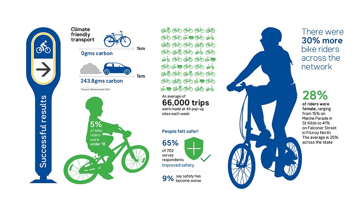
- Each week an average of 66,000 trips were made across 44 pop-up sites.
- There were 30% more riders across the network.
- Heidelberg Road recorded 600,000 trips between January 2021 and April 2023.
- Sixty-five percent of drivers, bike riders and pedestrians surveyed said the routes improved safety.
- Twenty-eight percent of riders were female, the average is 25% across the state.
What worked
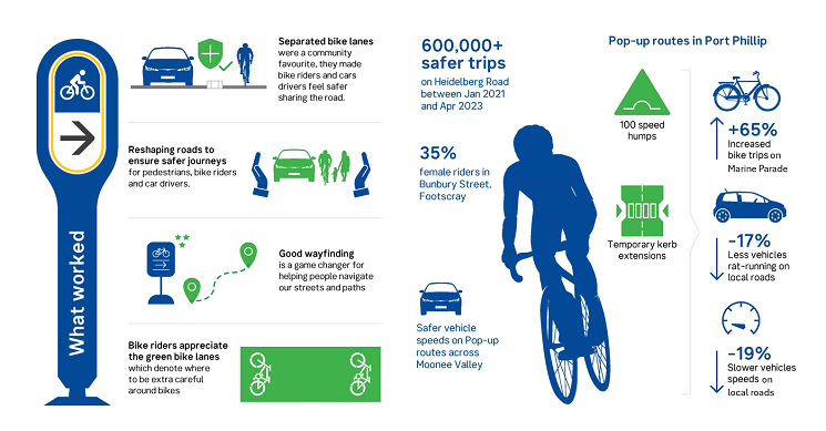
Separated bike lanes were a community favourite, they made bike riders and drivers feel safer sharing the road.
- Reshaping roads to ensure safer journeys for pedestrians, bike riders and drivers.
- Good wayfinding is a game changer for helping people navigate our streets and paths.
- People appreciate green bike lanes which denote where to be extra careful around bikes.
Next steps
- We're working with councils to make most of the pop-up infrastructure permanent.
- We’ll update the community to confirm where and when these works will take place.
- We plan to complete the transformation by mid-2025.
- We'll consult with the community on the proposed designs for permanent infrastructure on Marine Parade (Port Phillip) in 2024.
- We'll work with stakeholders on proposed designs for the Heidelberg Road (Yarra/Darebin) bike lane.
About the project
No matter where we live, it’s important for everyone in our community to access and enjoy our streets. That means joining up the missing links in our neighbourhood transport network with more paths, crossings, safer bike riding and walking options for everyone to enjoy.
We know that Victorians enjoy walking and bike riding in their neighbourhoods. In fact, 76% of Victorians tell us they want to walk and bike more, and would do so if they had more paths, crossings and calmer streets.
That’s why we tested innovative and safer bike riding treatments to improve safety for all road-users, encourage more people to ride bikes and create better connections to the CBD and local activity centres.
Learn more about what we did and where in the drop-down menus below.
We commenced construction on the City of Port Phillip pop-up bike routes in May 2022 and collected valuable data throughout the trial period.
On local roads where light touch treatments including speed humps were used, rat running by vehicles was down 17% and vehicle speeds declined by 19%.
The pop-up bike routes on the majority of local roads within the City of Port Phillip were removed following a formal request from Council.
Improvements for bike riders on Marine Parade remained following trial findings.
Ridership along Marine Parade increased during the trial, including a 71% increase in commuter riding. Perceptions of safety also rose, with 69% of people surveyed on Marine Parade saying the pop-up bike lanes had improved safety for them while they ride.
Provide your feedback
We’re now consulting on three options to understand community sentiment on the next steps for bike lanes on Marine Parade:
- Option one: convert the temporary treatments into permanent infrastructure using kerb separators and white line markings to improve safety for all road users.
- Option two: remove the temporary kerb separators and bollards along Marine Parade but retain other safety improvements including green surface treatments, signage, and line marking.
- Option three: remove the temporary treatments and reinstate the original road condition. Green surface treatments will remain at some locations to raise awareness of people on bikes.
You can provide feedback and have your say at Engage Victoria.
You can also find out more about the project by attending a face-to-face drop-in session:
- Saturday, 17 August (09:30am – 11:30am), St Kilda Library 150 Carlisle Street, St Kilda.
- Tuesday, 27 August (06:00pm – 08:00pm), St Kilda Library 150 Carlisle Street, St Kilda.
- Tuesday, 3 September (9:30am – 11:30am), St Kilda Library 150 Carlisle Street, St Kilda.
- Saturday, 7 September (8:30am – 11:00am), Veg Out Farmers’ Market, Peanut Farm St Kilda.
Community feedback will inform how we progress.
Update - July 2024
Darebin and Yarra monitoring sites had high volumes of bike riders, ranging from 1,800 riders per week on Falconer Street to over 8,000 riders per week on Napier Street.
Due to the success of the routes in Darebin and Yarra, 100% of the routes on local roads will be made permanent:
- Local routes will be made permanent in consultation with Council, with works expected to take place in late 2024.
- We’re also introducing a safer speed limit of 50km/h on Westgarth Street to improve safety for all road users.
- Heidelberg Road and the intersection of Napier Street and Queens Parade require further planning, we will update the community in coming months.
- Temporary infrastructure on Wellington Street will remain pending results of a Council led community consultation.
We will communicate with the community about where and when these works will take place in coming months.
We started with the Heidelberg Road Link in December 2020 to improve connections from Darebin to the CBD.
The Heidelberg Road Link provides a combination of separated bike lanes on busy roads, new signage and line markings along quieter streets, and better connections to our on- and off-road networks.
See our before and after video to see what the Heidelberg Road Link looks like in action:
In April 2021, we announced planning for the Darebin and Yarra Connectors and St Georges Road Off-road Routes.
The Darebin and Yarra Connectors improve connections to surrounding suburbs and make the core link from Station Street to Wellington and Napier streets more effective commuter routes.
The St Georges Road Off-road Routes improve bike riding access across the Merri Creek Trail to the Inner Circle Rail Trail, connecting the journey between Preston and Melbourne’s CBD.
Together, the routes are making it safer for residents around Clifton Hill, North Fitzroy and Fairfield to ride to and from the CBD and within the local area.

View a larger version of the map
We trialled almost 13 kilometres of new and improved pop-up bike routes around Footscray, Seddon, and Yarraville.
The routes provide better local connections in and around central Footscray and make it easier for bike riders to get to and from Melbourne’s CBD.
The Footscray area includes a number of major projects like the West Gate Tunnel Project and Footscray Hospital. When completed, these will significantly change transport movements in the area.
The pop-up bike routes are forerunners to these works and support Maribyrnong City Council’s Integrated Transport Strategy and Bicycle Strategy 2020-2030.
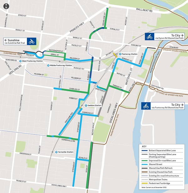
View a larger version of the map
Update - July 2024
Moonee Valley evaluation showed encouraging trends in women riding bikes and in people using the routes to connect to the Moonee Ponds Creek Trail to travel between Moonee Ponds and the CBD.
We’re working with Council to determine which routes will be made white and become permanent and we’ll be in touch in coming months to let you know when the work to make these routes permanent will take place.
Mount Alexander Road
Due to works being undertaken on Mount Alexander Road at the same time as the delivery of other Moonee Valley Routes, this pop-up route was not able to be delivered during the project.
Mount Alexander Road is a key route used by buses, trams, cars, bike riders and pedestrians, so it’s important we find the right balance for all road use.
We trialled almost 20 kilometres of new and improved pop-up bike routes across Moonee Ponds, Essendon and Travancore.
The routes help support local bike riding connections to schools, recreation and activity centres across Moonee Ponds, Essendon and Travancore.
The bike routes also provide congestion relief for the Moonee Ponds Creek Trail, with improved 24/7, all-weather on-road routes.
These improvements to bike routes in Moonee Ponds support Moonee Valley City Council’s Integrated Transport Plan and Moonee Valley’s 2040 Strategy.
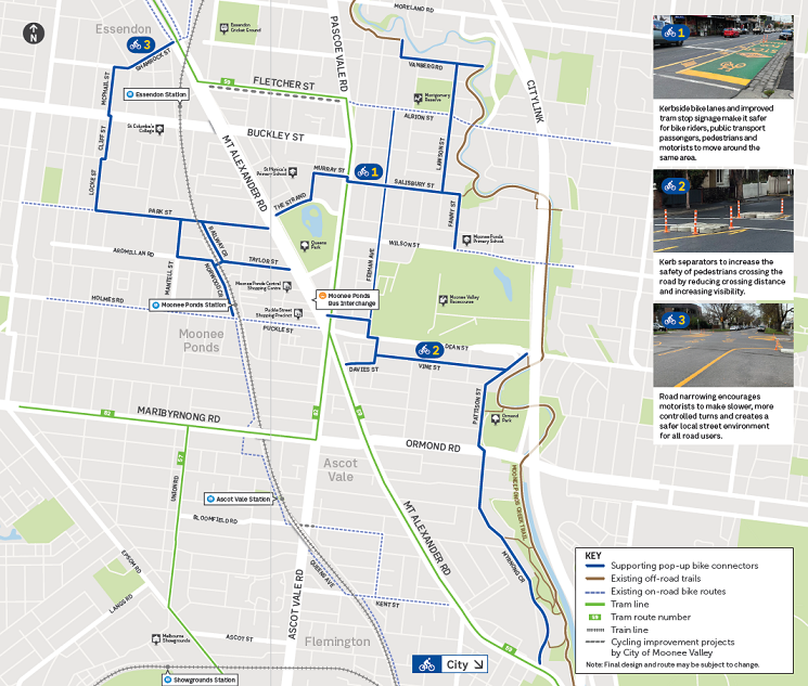
View a larger version of the map
ALL CONTENT BELOW THIS BOX WILL APPEAR IN THE RIGHT HAND COLUMN
For more information email us at [email protected]